A brief history of the
Armenian cartography
Edic Baghdasarian (Ed.
Germanic)
Armenian Research Center, Toronto
Introduction: It is
necessary to study maps history – facts, stages and patterns of its historical
development as practice industry, science and culture because it gives right
interpretation of modern situation and ways of future progress in cartography. First of all this progress is determined by
financial need of society. That’s why it is impossible to understand and
explain this progress ignoring specific social conditions, away from the
process of production forces development and production relations. Emerging needs
of society arouse the necessity in creation previously unknown maps and
therefore pose new challenges to the theory. Successful and progressive solving
of these problems contributes and even creates necessary conditions for solving
practical problems and at the same time encourages further advancement of
cartography.
The history of cartography studies the development of maps as well
as methods of its creation and the development of the theoretical foundations
of science.
The history of cartography is considered together with common historical
periodization as far as development of cartography was always determined by
life needs, demands in production which were seriously changing in various
social and economic structures.
Cartography did not arose
as a fully developed science or even art; it developed slowly and with
difficulty, the sources of its origin are in the clouds. The
first and the most important stage of its development starts in the last
century of the pre-Christian era, in Alexandria, Egypt, the Roman capital.
This city, located just 12 miles from the mouth of the Nile, was at that time
the largest information center, where news from the whole world flow. Richly endowed with natural wonders, Alexandria was
able to significantly augment inheritance masterpieces of architecture, art
treasures and books; the beauty and the value of which rivaled only with the
Eternal City. Alexandria became a true center of the Hellenic world, alluring
beacon for travelers and a haven for scientists - a city where people could
think.[1]
Geographical knowledge in Armenia stands out against a
background. Despite the devastation, which had suffered Armenia, being situated
between Byzantium and Iran, Armenian feudal culture was rather high in V-VII
centuries. Armenians knew several geographical works of Greeks including
"Geography" of Ptolemy. Armenian "geography" of Anania Shirakatsi (610-685) was
created on the basis of Ptolemy “Geography” in the beginning of VII c. and
contained an extensive text, survived to the present day, and at least 15 maps,
including a map of the world, unfortunately lost. Text part was similar to the
work of Ptolemy, giving description of the Earth and its inhabitable part, but
it contained original material about Armenia and the countries of Asia Minor.
The author of the Armenian "geography" understood that it would be
very useful to draw attention to Armenian provinces, although it will require
studying maps and books. Thus, the geographical works and maps were not an
isolated phenomenon in Armenia. The importance of «Armenian geography" can
be gauged by the fact that Ptolemy work - scientific revelation for
cartographers and geographers of medieval Western Europe, became known here
only in XIV c.
So far about 60 copies of Ananai
Shiaraktsi’s Ashkharatsuyts
have reached us, of which 45 copies belong to Armenian Ancient Manuscript
Library of Mesrop Mastots (Matenadaran) in Yerevan and the rest are in the Armenian
libraries of Venice, Vienna, Jerusalem, etc.
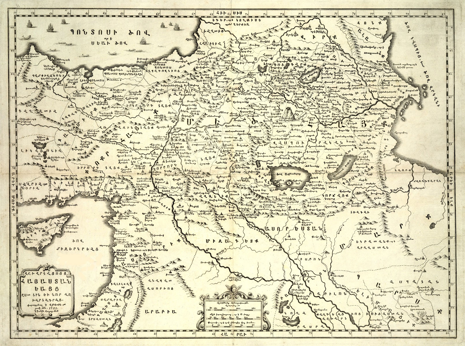
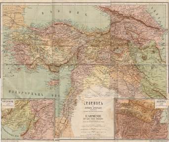
The Map of the Armenia as per the Ashkharhatsuyts printed in St. Lazzaro
in 1751.
There are two editions of Asharatsuyts:
Short and long versions.Short version was first
published in 1668 in Amesterdam at Voskan Yerevantsi’s printing
house, then in Marseille, Venice, Paris, Moscow, etc.
The long version was printed by A. Sukrian at Venice together with French translation in 1881.
The book, written in classical Armenian, has been
translated into modern Armenian, Latin, French
and German, as well as reprinted with an introduction in English and the
section related to Iran was translated from German (J. Marquart’s
Eranshahr) into Persian in1994
at Tehran .
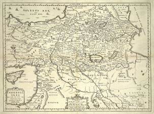
In the eighteenth century a map of historic Armenia
was printed at the St. Lazarus (San Lazzaro) Armenian
Monastery of Venice, prepared and etched according to the descriptions provided
in Ashkharhatsuyts.
Main part of Ashkharhatsuyts
consists of description of geography of Armenia, Caucasus ans
Sasanian Iran.So Ashkharatsuyts is a completely unique work. His focus is on
Eastern Roman Emire especially Greece, so that he
tried to find a relation between Armenian and Greek people based on historical
facts. Description of Asia Minor is significant, he
calls it “Mij-yerkriank” or “Mediterrane”.
He describes the countries of Asia Minor at 6-7th centuries. He
explains about some administrative divisions that did not exist at the time of
Ptolemy and Pappus of Alexandria, for example Onoria,
Elinopoltus First Armenia, Second Armenia, etc.

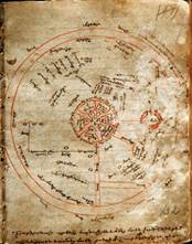
Globus according to Anania
Shirakatsi’s Geography,
reconstructed by prof.
Suren Yeremian
One of the best and unique sections of Ashkharatuyts beside Greater Armenia, Virk
(Georgia), Albania and “Sarmatia”, can be considered “About Persia” chapter. Anania completely ignors Ptolemy
and presents completely unique descrition about Sasanian Iran’s political-administrative divisions. This
chapter later became a subject for Prof. J. Marquart
for his book “Eranshahr”, which is translated into
Persian in 1994[2].
Shirakatsi compared
to Ptolemy, presents a systematic approach based on maps:
First map: Overal map of the
world, covering all next 14 maps)
2nd map:
European part of the Western Roman Empire including European Sarmatia.
3rd map:
European part of the Eastern Roman Empire including European Sarmatia.
4th map:
Corresponds with Ptolemy’s Asiae tabula prima.
5th map: Mediterrane.
6th map:
Corresponds with Ptolemy’s Asiae tabula secunda.
7th map:
Corresponds with Ptolemy’s Asiae tabula tertia. Colchidis, Iberiae, Albaniae, Armeniae Maioris.
8th map:
Corresponding with Ptolemy’s Asiae tabula IV.
9th map: Sasanian Iran “Eranshahr”
10th map:
corresponding with Ptolemy’s Asiae tabula V.
11th map: Scythia
12th map: India
13th map: Taprobana (Ceylon) island
14th map: China
15th map:
Indo-China[3]
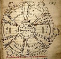
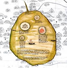
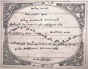
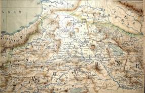
Armenian map of 13th-14th centuries. Matenadaran,
Ms. 1242 Matenadaran, Yerevan.
The oldest circular map in Armenian dates from the
thirteenth to fourteenth century. This is a T-O map, with all the attributes of
this type of maps. This small map is kept in Matenadaran,
bound in a manuscript from Kaffa (Theodosia) of
Crimea.
It has east at the top and shows the circular world
with Jerusalem and its six gates, drawn disproportionally large, placed at its centre. On the top semicircle – Asia – we can find the
cities of the Silk Road, extending from Zayton and Kansayh in China to Kaffa on the
Black Sea. Other trading cities of Sarai, Khawrazm, Azokh, as well as Mardin, Baghdad, Damascus, Venice, Cyprus are also shown.
The Red Sea is placed between Asia and Africa (below right) and is painted red.
Armenian map of Jerusalem. Matenadaran,
Ms. 1770[4]
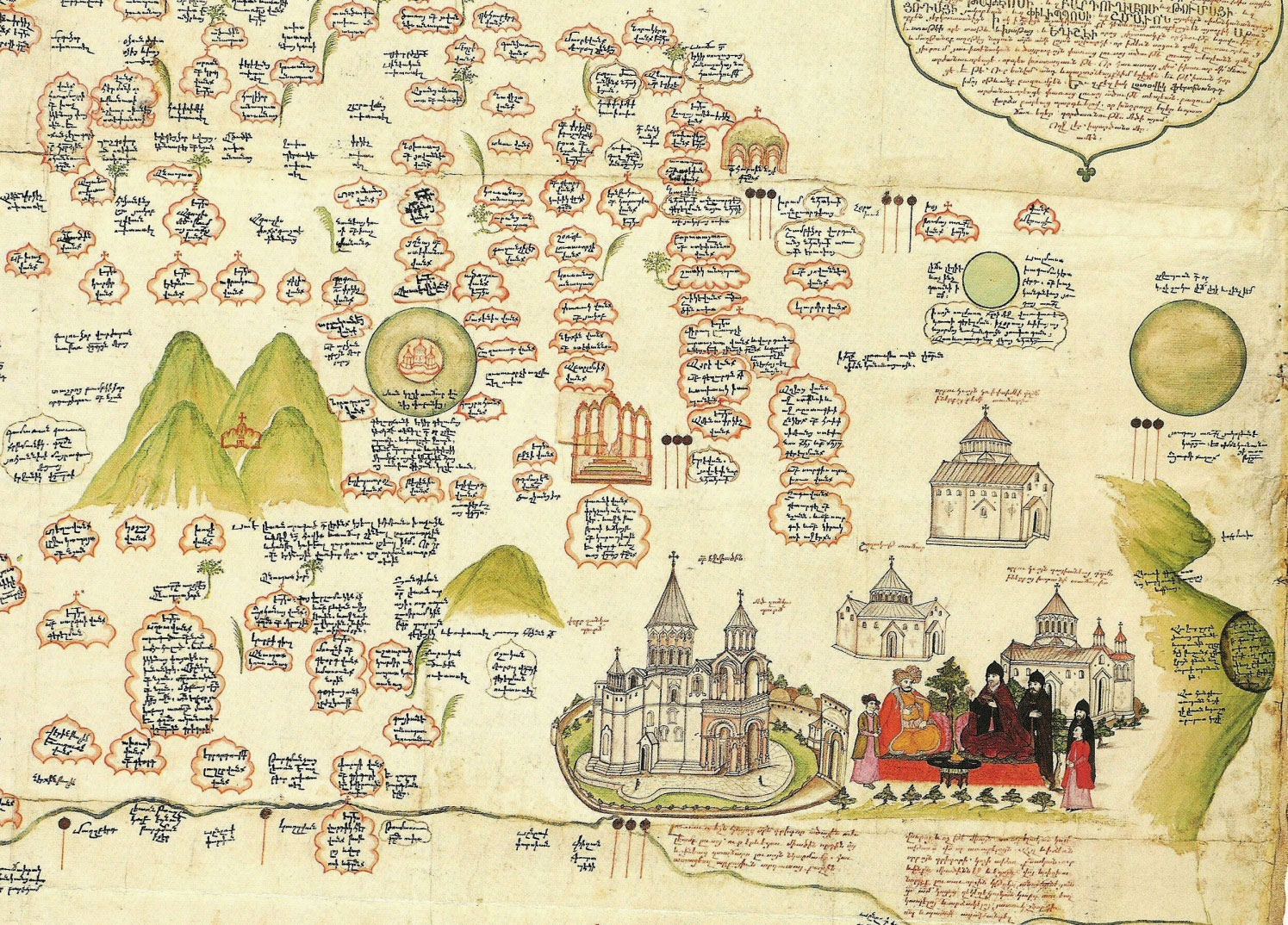
This is a detail from the Armenian map dated 1691,
made by the famous Armenian scholar and politician Eremia
Cheleby Keomurjian
(1637-1695) in Constantinople. It shows all the important Armenian churches,
monasteries and religious centres. Here we see Mount
Ararat near Echmiadzin, where the Catholicos
is entertaining the Persian Sardar, the four peaked Aragatz is north (left) of Echmiadzin
with the Monastery of Saghmosavanq and other churches
found nearby, each with a relevant description in a cartouche[5].
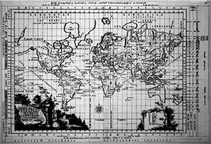
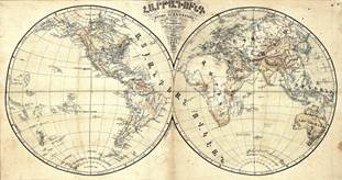
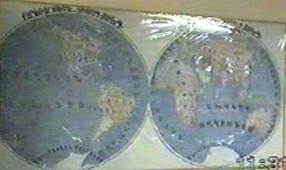
The third oldest Armenian map is the World Map
printed in 1695 by Tovmas Vanandetsi
in Amsterdam. This map consists of the two hemispheres, America and Australia
being incomplete. The cartographers being of Dutch origin had utilised all the latest cartographic information and
up-to-date styles used in the Netherlands of the time. The map is
beautifully prepared and elaborately decorated. At each corner there are scenes
related to the four seasons as well as astrological and mythological figures.
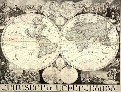
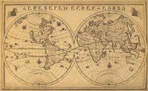
Hamatarads Ashkharhatsuyts, the first printed Armenian
language world map, printed in 1695, Armenian publishing house in Amsterdam
Yeremia Chelebi
Keomurjian,The
sanctuaries and pilgrims of the Lake Van
A large-scale atlas of the world was printed in
Venice in 1849, with maps of the world, the solar system and each
continent, as well as maps of the Ottoman Empire and Armenia, all beautifully
laid out and coloured. This is considered to be the
first full atlas in the Armenian language[6].

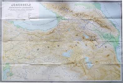
Historical
atlas of Armenia, Venice 1849
The Monastery of St. Lazarus and its printing house
have a significant place in Armenian cartography, as from the early eighteenth
century for almost two hundred years the most important maps in the Armenian
language were printed there. (See Fig. below ).
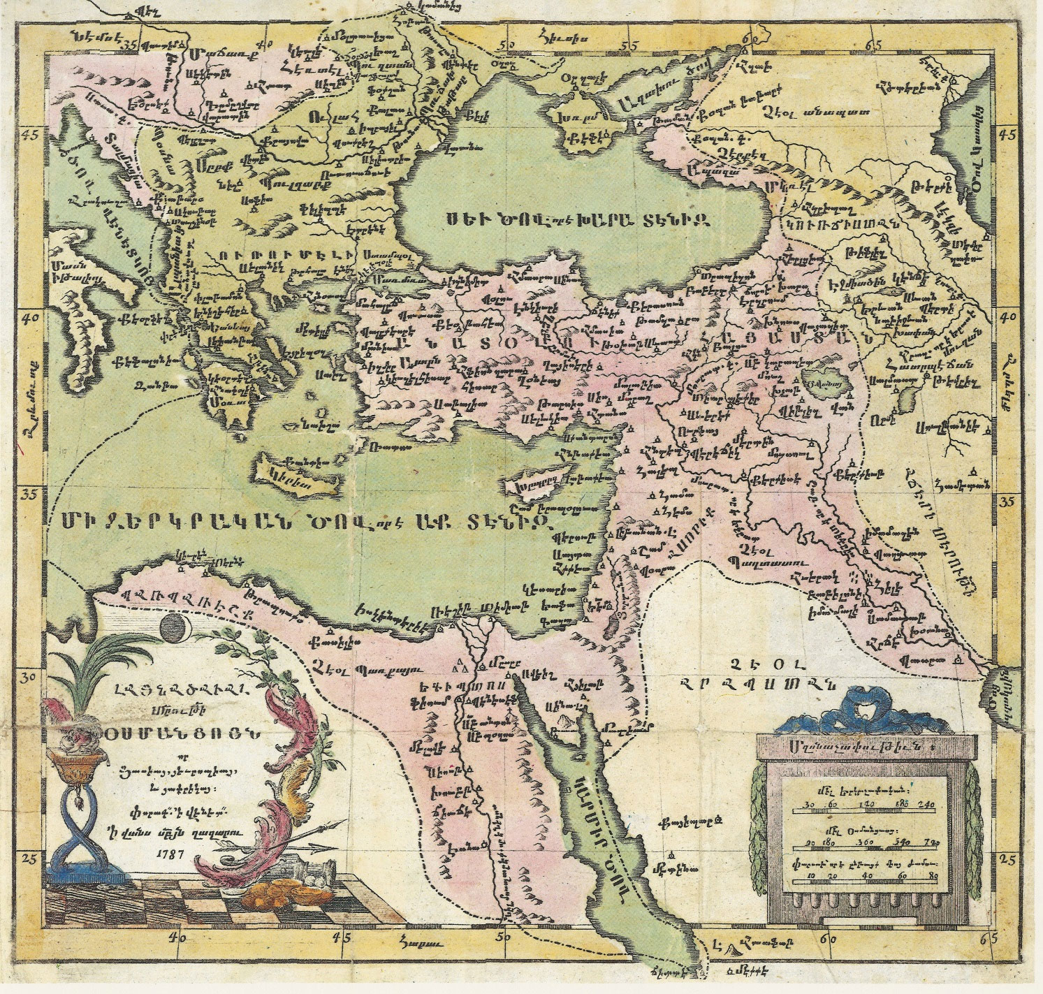
Armenian language map of the Ottoman Empire, printed in the Venetian Armenian Monastery of St. Lazzaro in 1787.
Hamatarads Ashkharatuyts, Venice, 1747
Ashkharatsuyts, Venice,
1751
Armenian
map of geographical zones. Matenadaran,
Ms. 1780
In 1778 “Ashkharatsuyts Hayastaniayts” (Map of Armenia) which was prepared by Sultanian in Madras city of India, was printed in Venice.
Michael Chamchian
included his map of Armenia in the first volume of his three-volume History of
Armenia, printed in Venice in 1784.
Michael Chamchian, Venice 1784
Armenian
map of the
world, 1784

Armenian
map of Africa
Since the middle of the nineteenth century, maps
have become more accurate and reliable, their differences lying mainly in such
relatively minor matters as place-names, scales, projection and detail.
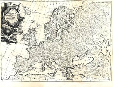
Armenian map of Europe, St. Lazarus,
Venice, 1786,
By Yeghia Entazian
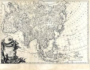
Armenian map of Asia, St. Lazarus,
Venice, 1787,
By Yeghia Entazian
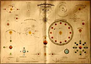
Armenian
map of planets, Venice, supported by
Tatian Amira
It took much time and effort on the part of many
geographers and cartographers to achieve this greater reliability. During the
same period, in some maps the name of Armenia was gradually being substituted
with other more ‘acceptable’ terminology, depending on who was the
producer and where the map was printed.
Historical
map of Armenia, printed in Venice, 1849
However, the reasons behind these changes were
political rather than cartographic.
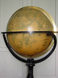
Armenian
Globus, Vienna, 1850
Global cartography reached maturity in 1891, when
the Fifth International Geographic Congress approved the execution of the
International Map of the World with a scale of 1/1,000,000. It was only after
this final decision that the world could be properly surveyed, pending peace
and the proper cooperation of the member states, both of which conditions are
often elusive, even today.
Map of Armenia, Vienna, 1860
Chitchian prepared a world
map in 1892 in city of Van (Western Armenia, under Turkish occupation). He
called it “Hartagund” (Flat sphere).
“Hartagund”
(Flat sphere)
In 1904 Armenian Student association of Geneva
published “Armenia and neighboring countries” map prepared by H. P. Manisachian.
Lake Van,
from travel account of Nerses Sargisian
Map of
Armenia, by Manisachian, 1904
Vartanian prepared a
historical map of Armenia in Tbilisi in 1910 (the following)[7]:
Megerdich Kheranian of Van, prepared map of Van in 1913. It is
hand-made on silk cloth.
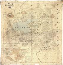
Map of
Van, by Megerdich Kheranian,
1913
During my several visits to Armenian
cultural-religious complex (Cathedral, Museum, Pprinting
house, Library, etc.) at New Julfa of Isfahan, Iran
for my research on History of Armenians in Iran[8], I
observed a few old maps prepared by Megerdich Kheranian in 1928, here are pictures taken from the video I
prepared at 1997. One of them is “Armenia and neighboring Countries” which a
copy of it is in Echmiadzin, and the other one is two
hemispheres, both of them are handmade on cloth, as the following figures:
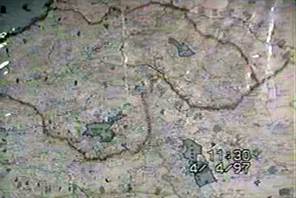
Armenia and neighboring vountries,
by Kheranian, 1928
Thwo hemispheres by Kheranian,
1928
After establishment of Soviet Armenia (Nov. 29, 1920) New era for the Armenian people began. Along
with all other fields of Science, culture, industry, economy, agriculture, etc.
Geography and cartography researches were planned and performed on systematic
basis. For example in 1940 more than 90 Armenian maps were prepared, So far
starting 1920, hundreds of maps in Armenian have been published in Armenia.
Although we have mentioned some of the Armenian
geographers of Soviet Armenia and Republic of Armenia in previous sections , but It is appropriate to give a few lines about
Academician, Prof. Suren Yeremian
who can be called “Father of Geograpghy and Cartography
of modern era of Armenia”.
The maps drawn by S.Yeremyan have taken their
stable position in the treasury of historical cartography. By comparing the
data of antique cartographical sources, particularly those of “Manual of
Geography” by Claudius Ptolemy (“Third map of Asia”) to the data provided by
“Ashkharhatsuyts” [(«Աշխարհացոյց»-World
Atlas) the authors of which are Movses Khorenatsi (the 5th century) and the
continuer and editor of his work, Anania Shirakatsi (the 7th century)],
S.Yeremyan drew the map of the Kingdom of Great Armenia. He created a valuable
book and map, “Armenia according to Ashkharhatsuyts”. Owing to all of this
Suren Yeremyan created a valuable book and map, “Armenia according to
Ashkharhatsuyts”1. He also began restoring the initial original of
“Ashkharhatsuyts” and published several of the 15 maps of the World Atlas.
S.Yeremyan published the map of “the known world” (the oikumene) as well. It
occupied only one part of the globe of the earth, the model of which S.Yeremyan
restored, according to “Ashkharhatsuyts”.
With their accuracy S. Yeremyan’s maps containing
the Armenian Highland and Great Armenia serve the purpose of solving
historiographical problems in scientific and socio-political spheres,
preserving the historical memory for future generations and truthfully
presenting the historical picture of the Armenian territories. He remained true
to his calling, working in the sphere of historical cartography. Among the
voluminous maps dedicated to different epochs of Armenian history and published
in recent years, the map dedicated to the Armenian empire of Tigran II the
Great has a special significance. S.Yeremyan continued the traditions developed
by previous generations of Armenian historians and cartographers, thus greatly
contributing to the progress of the Armenological school of historical
geography and cartography.
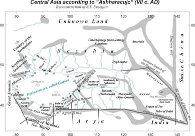
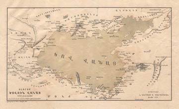
Central Asia according to Ashkharatsuyts,
of Shirakatsi, by S. Yeremian
Studies
of old maps have started relatively not very long ago,
as they were initially limited to only facsimile edition of separate maps or
collections and maps history, while nowadays, maps are also used for
cartographic research.
Interest
in cartography history has i ncreased
in the late 18th
and early 19th
centuries, which was due to extensive development of the economy and the
transportation network and the need for accurate mapping data for armies. At
that time Europe began to publish copies of old maps with scientific comments.
One
of the first such works is the “Atlas of Old Maps” published by French scientist M. F.
Santarem (1791-1855)1 and “History of Cosmography”. In 1842-1862 E. F. Zhomar
(1777-1862) published "Monuments of Geography History" collection
etc.
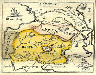
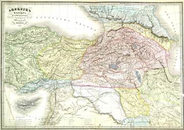
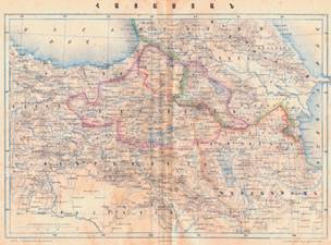
Map of Greater
Armenia (Eastern and Western Armenia) and Cilicia
Armenian
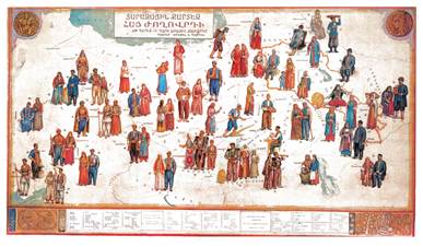
traditional costumes according to geographical locations
Until
the mid-20th century, most of the scientific works were mainly
devoted to the history of maps and biographies of outstanding cartographers,
but from the 1950s onward researchers of old maps put
some new subjects on the table. The complex approaches were typical for these
new works. Significantly cartography history, cosmography, astronomy,
mathematics and other
sciences were interrelated and linked.
The
first of our well-known cartographic publications, is "Armenian
cartographic publications in 260 years (1695-1955)" published in Yerevan
in 1957. The first collection about old maps of Armenia was a collection consisting of
25 maps, "The Overview of Armenia's Geographical Unit" by Geographer-cartographer admiral Zatik Khanzadian (born in Manasa Western
Armenia in 1886 died in1980 Paris). In 1960 he
compiled collection of large number of maps in "Atlas of Historical
Geography of Armenia", dedicating it to the glorious 40th anniversary of Soviet Armenia. Atlas
consists of maps of ancient times up to the present time.
In
1961 the " Atlas of the Armenian Soviet Socialist
Republic" was published by editorship of A. Baghdasarian
in Yerevan-Moscow, whose last Two pages are entitled "The Image of Armenia
on Old Maps". Here are the seven maps depicting the territory of Armenia
by title, without comments.
In 1976 an article
titled " Armenian Medieval Oval map", was published by M.M. Khachatrian[9].
In
2004 R. Galchian published a luxury collection of
"Historical Maps of Armenia, Cartographic Heritage".
In
2004, collection of 4 maps on "Armenia in the World's Oldest Maps"
was Published by P. Tekeyan.
In
2004-2012 B. Harutyunyan publishes a three-volume
"Atlas of History of Armenia" Collections of maps have not only
cognitive and scientific but also political importance.